|
|
|
|
With GPS now common, many people use coordinates than formerly. These come as either latitude and longitude, or East and North. The most common example of this, is how Australia changed its mapping, navigation and positioning systems to a new datum - the Geocentric Datum of Australia 1994, or GDA94. Put simply, all coordinates - latitude, longitude, east and north - will alter by between 130 and 170 metres each. This change took place during 2000-2001, but still impacts on everyone who uses
The changeover was adopted by both state and commonwealth governments and means, in practice, that all Australians need to adjust.
The government rationale was to bring our map systems into line with international usage, and with modern positioning technologies, particularly the Global Positioning System (GPS). A point located relative to the new datum will be approximately 200metres south-west of the point denoted by the same latitude and longitude on the previous datum.
Conversion does NOT mean that permits, structures or points will move. However, wherever locations are mapped or stored in latitude and longitude, or in east and north, those coordinate values WILL change. Nor will it affect ownership of permits, leases, etc. But it WILL open significant risks of confusion and 200m errors.
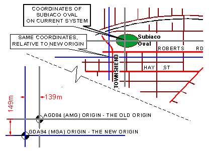
The new datum - the base from which coordinates are measured - is named GDA94 (or just GDA). Maps based on a Transverse Mercator projection from this datum will be referred to as MGA, or Map Grid of Australia. GDA and MGA will replace AGD(84) and AMG respectively.
Prevention is better than cure.
With planning, and with assistance where you cannot divert the resources yourself, changeover to GDA is easily managed. Geoproject Solutions hopes this information will be useful, and would be pleased to provide any further assistance.
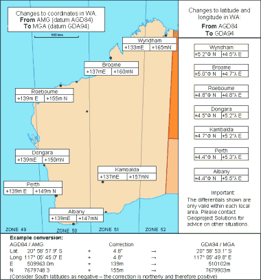
This map shows the differences in coordinates at specific locations.
|
|
|
|